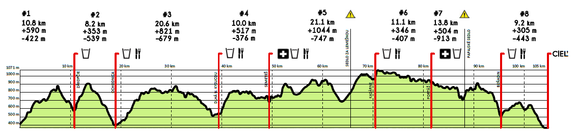
COURSE
Total distance: 106 km
Total positive altitude change: +4030 m
Course profile:
Click on the picture to increase the size.
Javornícka stovka course map and GPX file:
► Course map (source: TuristickaMapa.sk)
► GPX file for the Javornícka stovka course
Start and finish place:
The start place is Námestie slobody square in Čadca (in front of the municipal hall).
The race finish is located in Lysá pod Makytou in the elementary school building.
Course description with tourist marking colors:
, Čadca, Námestie slobody ► Kýčera ► Črchľa ► Point where you will turn left to the yellow tourist mark (before reaching the signpost Grečovci) ► Zákopčie, U Holých ► Blažková ► Chotárny kopec ► Belajky ► Ochodnica ► Klimkovci ► Mičekovci ► Vrchrieka nad Petránkami ► Pod Jakubovským vrchom ► Strakovci ► Bogáňovci ► Valčuhovci ► Dlhá nad Kysucou ► Kamenité ► Bielovci ► Semeteš ► Solíkovci ► Vrchrieka ► U Melocíka ► Pod Čerenkou ► Nad Zápačou ► U Lovásov, sedlo ► U Lovásov ► Makov, Kopanice ► Sedlo pod Lemešnou (asphalt road only) ► Pod Soliskom ► Sedlo pod Hričovcom ► Butorky ► Kasárne, chaty ► Hotel Fran ► up the ski slope to the ridge ► Sedlo pod Veľkým Javorníkom ► Sedlo Gežov ► Stratenec ► Sedlo Bukovina ► Malý Javorník ► Sedlo Malý Javorník ► Frňovské sedlo ► Hotel Portáš ► Pod Kohútkou ► Chata Kohútka ► Provazné ► Krkostena ► Papajské sedlo ► Makyta ► Kyčera ► Kadalovci ► Beňadin ► Strakovce ► Paseky ► Sedlo Hrnčár ► Lysá pod Makytou
We recommned to use the Mozilla Firefox browser for the course description (other browsers may not display the course description correctly).
Checkpoints (aid stations) and its time limits:
| Checkpoint | Location | Map | Km from start * | Time limit |
| K1 | Zákopčie, U Holých | Link | 10,8 km | 8.10.2022 until 09:45 CET |
| K2 | Ochodnica, house nr. 225 | Link | 18,9 km | 8.10.2022 until 12:00 CET |
| K3 | Dlhá nad Kysucou, municipal office | Link | 39,5 km | 8.10.2022 until 17:30 CET |
| K4 | Semeteš, U Cipára | Link | 49,5 km | 8.10.2022 until 20:15 CET |
| K5 | Kasárne, Mountain hotel Fran | Link | 70,5 km | 9.10.2022 until 01:45 CET |
| K6 | Portáš, Mountain hotel Portáš | Link | 81,6 km | 9.10.2022 until 04.45 CET |
| K7 | Beňadin, private hut | Link | 95,4 km | 9.10.2022 until 08:30 CET |
* The information about distance (km from start) is just for your guidance.
WARNING: Beside the live checkpoints mestioned in above table please calculate with one ore more live check points not mentioned in the list. It will be placed visibly on the course, therfore it will be not possible to miss that checkpoints if following the race course.
The race organizer resereves the right to change the course, the location and time limits of the checkpoints (aid stations).
Course marking:
1.) Standard tourist marking
2.) Information about own (additional) marking will be provided before start.